|
AN AMATEUR GEOLOGY
ROAD TRIP
My travels through the Colorado Plateau of southern Utah and northern Arizona. by John Fuhring June, 2010 Page 4
One thing I wanted to stop off at was Grosvenor
Arch, named after the famous director of the National Geographic
Society back when I was a kid and the man who made the organization
world famous for photography and popular stories of our natural world.
From my maps I was under the impression that it was a goodly
distance from the Cottonwood Canyon Road and that I'd probably have to
park at some wide spot and get out my mountain bike. Turned out
that there is a road that takes you all the way to the arch where
you will find an unexpectedly nice park with clean toilets, beautiful
scenery, interpretive signs, a paved walk to the Arch(es) and nice
picnic facilities.Speaking of the National Geographic Society, I got into a very nice discussion with a guy about my age (or a little younger) who was part of a larger party visiting the Arch. These people were from all over the U.S. and were being shown the wonders of the Colorado Plateau by a professional National Geographic Society guide. The guide drove the 4WD vehicle, did all the explaining, and made arrangements for them to have good meals and comfortable, air conditioned lodgings at night. Nice way to go. Outside of college field trips (which are never so deluxe), I had never heard of this kind of service before, but I could see where it would really appeal to older people interested in seeing more than just pretty rocks. I had to laugh to myself thinking that I was on an almost identical mission at the same time and place as these folks except my guide was me and I was on my own with regard to food and lodging. With just a tent and cot for my lodging and a gas cook stove and a bunch of unappetizing canned goods for my meals, I was at a distinct disadvantage in some respects, but I did have the fun and adventure of being on my own and traveling where I wanted to and seeing what I wanted to see. With the help of renowned geologists like Hintze, Blakey and Ranney I had the guides I needed. As mentioned, I had a nice discussion with the guy and, if I say so myself, I went into a little more detail regarding the local geology (thanks to Professor Hintze's excellent book) than what he had gotten from his professional guide. 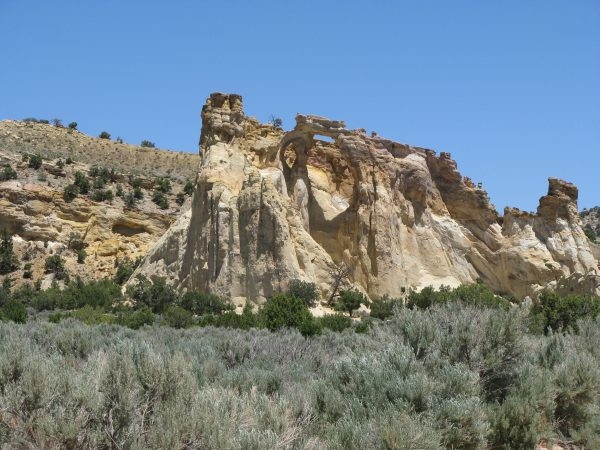 Grosvenor Arch as seen near the parking lot. 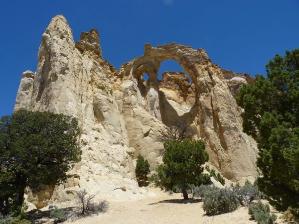 Looking up from the end of the paved walk. This is a very pretty little park out in the middle of nowhere. 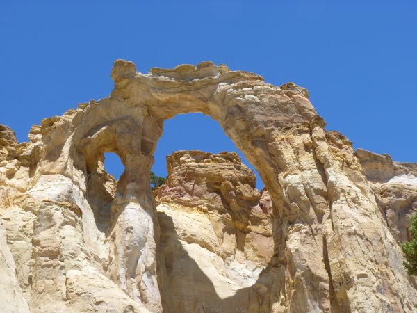 Unconformities can be seen between the three formations which were laid down during different parts of the Mesozoic and under different conditions. As you can see from the photo, it is really a double arch. A small one to the left and a big one to the right of that in this big monolith of sandstone. Actually the monolith is made of three very different kinds and ages of sandstone. The lower and oldest is the Henrieville Sandstone. Although not identified here as such, the Henrieville is now considered to be a "bleached" upper member of the famous Entrada Formation. This rock was laid down about 160 million years ago during the late-middle Jurassic (long after the more famous Navajo Sandstone) as beach sands. Above that there is a big time gap or unconformity indicating that a lot of erosion occurred during the remainder of the Jurassic. Deposition resumed during the middle Cretaceous to lay down the Cedar Mountain Sandstone which lies unconformably above the Henrieville. The Cedar Mountain Formation was laid down about 100-110 million years ago in sandy rivers and lakes and contains dinosaur remains, but I didn't see any bones sticking out of this stuff. This formation is one of the last to be really studied and it's revealing some pretty interesting stuff. It seems that the lower members of the Formation contain dinosaurs that appear similar to European species, but in later parts of the Formation, Asian type dinosaurs appear to have replaced the older ones indicating that major geologic changes were taking place on a large scale. At the very top of these arches and separated by another unconformity is a layer that the signs at the park identify as the Dakota Formation. You may know that the Dakota is famous as one of the world's great dinosaur graveyards. Recent work suggests that the rocks here should be considered part of the contemporaneous Naturita Formation because they were laid down in a way that was significantly different from what went on further east when the Dakota Formation was laid down. Besides that, the word 'Naturita' sounds so .. ah .. 'natural' and so .. ah .. 'green' and, most importantly, as every professional geologist knows, using terms that almost nobody has ever heard of sure makes you sound smart. They lend a certain gravitas to your pontifications. OK, I'm going to assume what we really have here is the Naturita and I'll be using that term from now on. The Naturita sands and gravels represents a major change that was just beginning to happen out to the west of the Colorado Plateau region as the effects of the Sevier Orogeny and sediments formed in the Western Inland Sea (Mancos Sea) would come to dominate this region. The Naturita sands and gravels were laid down at the very beginning of the Late Cretaceous, at least 5-10 million years after the Cedar Mountain stuff at about 95 million years ago. There are Naturita Sandstone boulders that have fallen down from the top of the arches and are lying about. They are reported to contain sea shells, but all I saw was medium sized particles of gravel and no matter how hard I looked, I found no sea shells in anything. Of course, I've always been terrible at finding fossils. 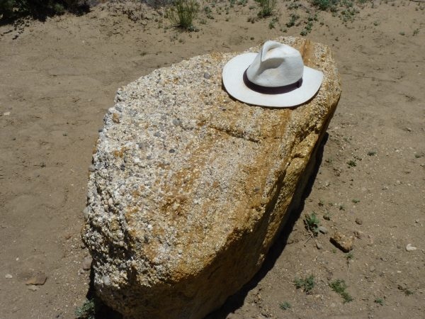 A gravel sandstone boulder. Probably a piece of Naturita Formation. While I was there I stopped and looked around at the scenery off in the distance and then I looked straight up. I thought to myself, "OK, so where's all the other stuff?" Where was all the later Cretaceous Mancos Shales and coal beds from the ancient swamps and all the other later sediments that should be in thick layers above me? Not for the first or last time I realized that sediments that were once there were now all gone. All eroded away and flushed, over a period of less than 6 millions of years, down the Colorado River to partially fill up the widening Sea of Cortez as this new sea expanded and continues to expand and rifts Baja California away from the mainland of Mexico. I took advantage of the nice facilities at the park to have lunch there, but soon got back on Cottonwood Canyon Road for the short trip to Kodachrome Basin. I was sorry that I hadn't taken my time going up the Cockscomb. I missed some really great hiking and especially some outstanding photographic opportunities by rushing as I did, but when I got to Kodachrome State Park, I was glad I got there early. |